Unlocking new insights into WA’s future climate
The most reliable and comprehensive Western Australian climate change projections to date are being produced with the help of Setonix – one of the world’s greenest, most powerful supercomputers.
The state-of-the-art projections will extend 75 years into the future and will help business, industry and all levels of government to better understand the impacts of climate change.
The project is part of the Climate Science Initiative being led by the WA Government Department of Water and Environmental Regulation in partnership with Murdoch University and the NSW Government Department of Planning and Environment via the NSW and Australian Regional Climate Modelling Project (NARCliM 2.0) and the Pawsey Supercomputing Research Centre.
The Challenge
Climate change is widespread, rapid and intensifying. Western Australia’s south-west has dried at one of the fastest rates in the world and is projected to continue drying. As temperatures increase, climate disasters are growing in size, frequency and intensity – often with little time in between for communities to recover.
Climate models are our best tool to understand how the climate may change in the future.
Global climate models divide the world into grid cells ranging from 150 to 280 kilometres in size. Because of their size, these cells are often too big to examine the impacts of climate change at local scales – such as for regions or towns.
To understand how climate change will impact specific regions or communities, scientists must first translate these large-scale global climate models into more detailed regional models.
These regional models better account for regional influences (e.g. mountains and coastlines), storms and extreme events but producing them is often limited by computational power and data storage.
Dr Jatin Kala, Senior Lecturer in Atmospheric Science at Murdoch University, is leading the Climate Science Initiative’s scientific team producing detailed climate projections for WA.
‘Global climate models are very good at simulating the very large-scale weather patterns across the entire globe, but they are not well suited for examining the impacts of climate change at local scales or for events like storms which occur on scales much smaller than the 150-280 km resolution of global models,’ Dr Kala said. ‘Regional climate models can help us understand how our climate may change and impact a specific region or community.’
The Solution
The Climate Science Initiative partnership will make it possible to produce the most detailed climate change projections for WA ever produced.
As part of the partnership, Pawsey is providing 40 million core hours, one of the largest allocations in Setonix to a single project, and 1.5 petabytes of data storage.
Dr Kala’s team will use Setonix to produce detailed climate change projections at a grid scale of four kilometres initially for the State’s southwest. National climate projections, which will include the state’s northwest at a grid scale of 20 kilometres, are being produced by the NSW Government as part of NARCliM2.0.
‘If you had to pay private supercomputer providers for this data storage, it would be millions of dollars. Pawsey is providing this in-kind under the partnership,’ Dr Kala said. ‘Even though we’ve been doing this sort of work for years, it has never been at this scale. We will run simulations from 1950 to 2100 at four-kilometre resolution. This includes two future climate scenarios with two different model configurations; this has never been done before.’
The Outcome
The first projections from the computer are expected to be available to climate scientists in 2024, which will then need to be analysed and processed for use by a broader audience.
Translating the science into local insights will be critical to helping non-specialists understand and apply the information. With this understanding, communities and businesses will be better placed to respond to climate impacts. The projections will also help government better protect the State’s unique biodiversity, prepare for climate extremes including tropical storms, floods and bushfires, and support major investment decisions in areas such as energy infrastructure, planning and regional development.
The project will also contribute to training graduate students in climate science by supporting two PhD scholarships.
For further information visit: wa.gov.au/climatescienceinitiative
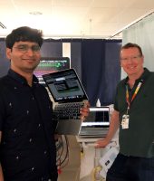
Project Leader.

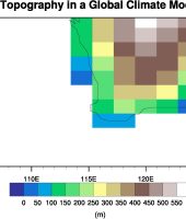
Topography (height above sea level) in a typical global climate model

Topography (height above sea level) in the 4 km regional climate model simulations that will be conducted.