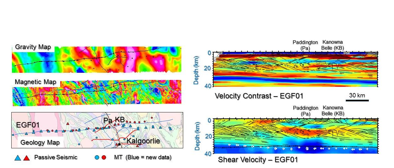
District-Scale Exploration for Gold Using Geophysical Methods
This project involved working with the WA State government through the Geological Survey of Western Australia. The key objective is developing 'district-scale' geophysical mineral exploration targeting methods. There is a scale gap at the district-scale such that there is a lack of 'targets' for geophysical methods as applied to exploration for sub-surface mineral deposits. New geological ideas involving district-scale 'palaeo-reservoirs' as prospectivity indicators were tested by seismic and electromagnetic surveys around known gold deposits north of Kalgoorlie. Detecting responses consistent with the 'palaeoreservoir' idea would represent strong encouragement that such targets are a means to fill the targeting-scale gap and would be highly significant both for State Government programmes encouraging mineral exploration and for the companies exploring for minerals.

Area of science
Geophysics
Systems used
Magnus
Applications used
MagnusThe Challenge
The challenge is to collect and model high quality geophysical data in a ‘hostile’ environment. Mining areas have high levels of geological noise and are usually geologically highly complex. The challenge was to collect high quality data and then, using the Pawsey facilities, model what are explected to be noisy and complex responses to see if they are consistent with the presence of ‘palaeoreservoirs’.
The Solution
The project is a 3 year project and as such is on-going. The seismic component is complete and we have created high quality images of how seismic velocity varies through the entire Earth’s crust in the study area (images supplied). It is clear that the crust in the central mineralised area is distinctly different to the surrounding less mineralised areas. The electromagnetic component of the project is on-going, having been delayed by travel restrictions associated with COVID-19, but is expected to begin in July 2020. Explaining why the mineralised crust is different requires integration of both seismic and electromagnetic data so is not yet completed. However, the seismic data represents key evidence for an important new interpretation of the geological history of the region – this being an unexpected outcome of the research.
The Outcome
The modelling of seismic and electromagnetic data is computationally expensive – without the Pawsey Centre’s resources it would be impractical to attempt to do so.
List of Publications
This report pertains to year 1 of a 3 year project. To date we have only presented at conferences (~5 separate occasions in Australia and overseas) but we have near final versions of several papers ready for submission. Most publications will be closer to the end of the 3 years.