Past and Future Temperature Extremes and Vegetation in Western Australia
Projecty98 aims to provide novel information on how climate change will impact Australia, with particular focus on southwest Western Australia. The project focuses on changes in climate extremes, such as fire weather, that can have devastating consequences on society

Area of science
Climate Science, Earth Sciences, Environmental Sciences
Systems used
Magnus, Zeus, Nimbus
Applications used
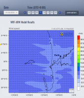
Weather Research and Forecasting (WRF) ModelThe Challenge
The south-west of Western Australia, a biodiversity hotspot and a region of significant agricultural production, is known to be vulnerable to climate change, with global models showing significant trends towards a warmer and drier climate across the entire south-west. However, Global Climate Models (GCMs) have a limited ability to simulate future climate changes at a more detailed local scale. To understand exactly how these changes will impact on the local environment, industries and communities in this region, and to plan appropriate response strategies, a more detailed regional climate projection is needed, and this is what project y98 aims to achieve.
The Solution
We use the Weather Research and Forecasting (WRF) model, an open source state-of-the-art regional atmospheric modelling system, to dynamically downscale global climate models from resolutions of 100-250 km, down to 2-10 km. This allows us to study atmospheric processes which have impact us in real life, such as heat-waves, floods, fire weather etc.
The Outcome
The Pawsey Centre’s Magnus supercomputer allows us to run the WRF model using several hundred’s of cores. The data storage facilities are also critical to our workflow as we produce hundreds of Terabytes of data, which have to be stored to be analysed later. We also use Zeus, as well as the Nimbus cloud server as part of our workflow. This work would be impossible without the computing services provided by the Pawsey Supercomputing Centre.
List of Publications
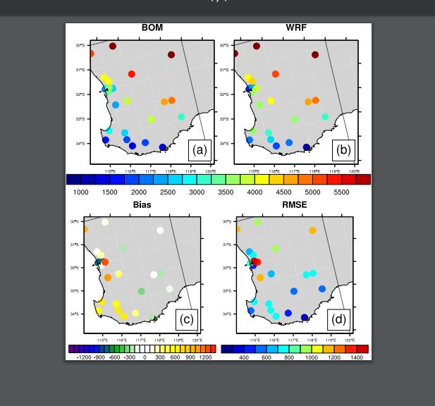
Kala, J., Sala Tenna, A., Rudloff D., Andrys J., Rieke, O., Lyons T. J. (2020) Evaluation of the Weather Research and Forecasting model in simulating fire weather for the south-west of Western Australia. International Journal of Wildland Fire, in press.
N. Liu, J. Kala, S. Liu, V. Haverd, B. Dell, K.R.J. Smettem, R. J. Harper. (2020) Drought can offset potential water use efficiency of forest ecosystems from rising atmospheric CO2. Journal of Environmental Sciences, 90, 262-274, doi.org/10.1016/j.jes.2019.11.020
Di Virgilio, G., Evans, J. P., Di Luca, A., Olson, R., Argüeso, D., Kala, J., Andrys, J., Hoffmann, P., Katzfey, J., Rockel, B. (2019) Evaluating reanalysis-driven CORDEX regional climate models over Australia: model performance and errors, Climate Dynamics, 53, 2985–3005, doi.org/10.1007/s00382-019-04672-w
A. L. Hirsch,J. P. Evans, G. Di Virgillio, S. E. Perkins-Kirkpatrick, D. Argüeso, A. J. Pitman, C. C. Carouge, J. Kala, J. Andrys, P. Petrelli, and B. Rockel. (2019) Amplification of Australian heatwaves via local land-atmosphere coupling. Journal of Geophysical Research – Atmospheres, 124, 13,625-13,647, doi.org/10.1029/2019JD030665