Past and Future Temperature Extremes and Vegetation in Western Australia
The southwest of Western Australia is a region of significant agricultural production and an internationally recognized biodiversity hotspot. Whilst the region is projected to experience a warmer, drier future, associated increases in variability are of concern to both agriculture and the native estate. Farmers will need to make sowing and variety choices not only to minimize frost risk whilst ensuring adequate soil moisture throughout the season but also to avoid temperature extremes during grain filling and conservation managers will need to adapt management strategies to ensure resiliency under a varying climate. This project will quantify the significance of temperature and rainfall extremes in both current and future climate on cropping and native vegetation through dynamical downscaling current and projected climate, to define the frequency of extreme events not only seasonally and spatially, but during key times in the biological calendar.
Area of science
Atmospheric Science
Systems used
Magnus, Zeus, Nimbus and Managed Storage
Applications used
Weather Research and Forecasting (WRF) model; netCDF, MPIThe Challenge
Global Climate Models (GCMs) provide very useful information about how climate is likely to change into the future. However, these models typically have resolutions of 100 km to 250 km. At such resolutions, the climate of Perth and Bunbury are essentially similar. To overcome this challenge, and provide meaningful simulations of climate at the regional scale, regional climate models can be used to dynamically downscale these GCMs from their coarse resolutions of 100 to 250 km, down to 5 to 10 km.
The Solution
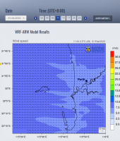
This project uses a state-of-the art regional climate model, the Weather Research and Forecasting (WRF) model, to dynamically downscale GCMs down to resolutions of 50 km across the whole of Australia, and 10 km over southwest Western Australia. We run the WRF model on the magnus super computer.
The Outcome
Over the past 5-6 years, we have produced a whole suit of regional climate projections for southwest Western Australia, and this is helping to inform all the different sectors (e.g., Agriculture, emergency services), better understand how the regional climate of southwest WA might change in the future and what is all means
List of Publications
D. D. Breshears, J. B. Fontaine, K. X. Ruthrof, J. P. Field, X. Fen, J. R. Burger, D. J. Law, J. Kala, Giles E. St. J. Hardy (2021) Underappreciated plant vulnerabilities to heat waves. New Phytologist, in press, https://doi.org/10.1111/nph.17348
P. Huang, K. Hennig, J. Kala, J. Andrys, M. R. Hipsey (2020) Climate change overtakes coastal engineering as the dominant driver of hydrological change in a large shallow lagoon. Hydrology and Earth System Sciences, 24, 5673–5697, doi.org/10.5194/hess-24-5673-2020
K. Wamahiu, J. Kala, J. Andrys (2020) Influence of bias-correcting global climate models for regional climate simulations over the CORDEX-Australasia domain using WRF. Theoretical and Applied Climatology, 142, 1493-1513, doi.org/10.1007/s00704-020-03254-9
J. Kala, A. L. Hirsch (2020) Could crop albedo modification reduce regional warming over Australia? Weather and Climate Extremes, 30, 100282, doi.org/10.1016/j.wace.2020.100282
J. Kala., A. Sala-Tenna, D. Rudloff, J. Andrys, O. Rieke, and T. J. Lyons (2020) Evaluation of the Weather Research and Forecasting model in simulating fire weather for the south-west of Western Australia. International Journal of Wildland Fire, 29, 779-792, doi.org/10.1071/WF19111
N. Liu, J. Kala, S. Liu, V. Haverd, B. Dell, K.R.J. Smettem, R. J. Harper. (2020) Drought can offset potential water use efficiency of forest ecosystems from rising atmospheric CO2. Journal of Environmental Sciences, 90, 262-274, doi.org/10.1016/j.jes.2019.11.020


