AI makes WA roads cheaper and safer
A ground-breaking Artificial Intelligence (AI) technology is poised to revolutionize traffic roundabout design globally. Engineers can now leverage drone-captured footage to analyse traffic flow at intersections, resulting in enhanced traffic modelling and prediction capabilities. This development is expected to lead to the creation of improved roundabout designs that are tailored to meet the demands of modern traffic. The implementation of such designs could effectively reduce road accidents and traffic congestion. The innovative AI model was developed through a partnership between Main Roads Western Australia, the Planning and Transport Research Centre (PATREC), and the Pawsey Supercomputing Research Centre.
The Challenge
The roads in Western Australia serve as vital arteries for transportation and supply. Poorly planned intersections along these roads can cause traffic congestion and increase the likelihood of accidents. Traditional traffic modelling methods depend on human surveyors to manually count vehicles, which can lead to inaccuracies due to human error. Additionally, it is difficult for humans to precisely measure variables such as vehicle velocity and distance for a large number of vehicles. As a result, these limitations can significantly impact the accuracy of intersection traffic estimates.
To address these challenges, a team of researchers and analysts from Main Roads Western Australia and PATREC have developed an innovative AI model for monitoring traffic flow at intersections. The model offers engineers an improved approach to planning new roundabouts or modifying existing ones to alleviate traffic issues. By leveraging the advanced capabilities of the AI model, engineers can design roundabouts that are more efficient, safer, and better suited for modern traffic demands.
Rafael Carvajal Cifuentes, Operational Modelling & Visualisation Manager at Main Roads was part of the project team. According to Rafael, human surveys suffer from an expected 10% error rate, which can increase or decrease depending on the surveyor.
Currently, intersections are monitored either by humans or stationary cameras that count the number of cars passing through throughout the day. This data is then fed into computer models that aim to represent the current situation and predict the performance of new intersection designs. However, these models rely on assumptions that can vary significantly across different regions of the world. Furthermore, they may not accurately reflect the behaviour of Western Australian drivers since they were developed using data obtained from other places.
The cost of a roundabout can range from tens of thousands to millions of dollars, depending on its size and features. Using more precise traffic models to predict the flow of traffic in response to new infrastructure can significantly improve the accuracy of expected performance compared to actual performance. By doing so, engineers can better design roundabouts that optimize safety and alleviate congestion, while also reducing the likelihood of costly remedial work being required.
The Solution
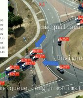
To develop the AI model, the research team utilized Pawsey’s Nimbus high-throughput computing cloud for both training and running the model. The model analysed video footage obtained from drone surveys of roads to identify traffic behaviour at intersections. According to Chao Sun, Senior Research Fellow at PATREC, drones provide data that cannot be obtained through human surveys. While humans can count cars, they cannot track factors such as speed, stopping, and the gap between vehicles with sub-second accuracy, which is essential for accurate traffic modelling.
Training the AI model involved numerous iterations, resulting in a significant improvement in both accuracy and processing speed. The team utilized the technology to analyse around 30 hours of high-resolution drone footage from approximately 40 roundabouts, with plans to double this amount in the future. This required a large amount of storage space and processing power to allow the machine-learning model to thoroughly analyse each video multiple times.
During the global shortage of GPUs caused by the COVID-19 pandemic, the Pawsey Nimbus provided the research team with remote access to GPUs, enabling them to continue their work and avoid months of lost progress. This was crucial as there were no suitable commercial suppliers available for the team, and they were unable to access GPUs from other cloud providers such as Microsoft or Google. The team relied heavily on Pawsey’s virtual machines to perform most of their computing.
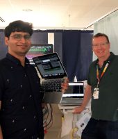
In addition to providing access to GPUs, Nimbus also offered data interactivity tools that enabled the team to develop a graphical user interface (GUI) for the AI model. This user-friendly interface allowed traffic engineers to interact with the model without requiring an in-depth knowledge of Python (software coding language). According to Chao, this GUI was crucial as traffic engineers prefer to use interfaces rather than Python notebooks. The team was able to develop the entire model and GUI on Nimbus, making it easy to hand over to users.
The Outcome
The AI model developed by the research team has demonstrated its ability to accurately observe traffic, as confirmed through cross-testing with traditional manual counting. The team is now scaling up the model to analyse dozens more hours of drone footage. This has the potential to not only improve transport infrastructure in Western Australia, but also globally. It could help avoid both over-investment and under-investment in roundabouts, leading to more efficient use of resources.
“One of the potential outcomes for traffic engineering is that we hope to provide better inputs into modelling software. Even for the modelling software that we currently work with, this is an opportunity to improve that software,” said Rafael.
The project is still ongoing, and the team plans to continue using Pawsey’s Nimbus cloud to train and further improve the model.
It’s great to see collaboration between Main Roads Western Australia, PATREC, and Pawsey to develop an AI model that can accurately monitor traffic flow at intersections. Using drone footage to collect data and machine learning algorithms to process it, the model can help engineers plan for new roundabouts or make changes to existing ones to alleviate traffic problems, improve safety, and reduce congestion.
The ability to predict the performance of a design and improve the accuracy of traffic modelling software can potentially have benefits not only in Western Australia but also worldwide. It’s exciting to see how technology can be used to address transportation challenges and improve infrastructure planning.
Project Leader.


